Missouri Map

Lightfoot Landing

Contact Info
Phone 1:
417-282-6890
Basics
Number of Sites:
38

Amenities

Basic Amenities
  • Drinking Water
Special Features
  • Playground
Additional Conveniences
  • Boat Ramp

Details

Season
Open year round.
Location
Getting There:
GPS Info. (Latitude, Longitude):
37.82611, -93.36139
37°49'34"N, 93°21'41"W

From Springfield, MO, go north on Highway 13 to Bolivar, MO. Take Highway 83 northeast to RB Highway. Follow the RB Highway east to the Lightfoot Park entrance.

Basic Info
Total Sites:
38
Tent Sites:
1
The lake is well known for fishing, with one of the highest catch ratios in the country. Species include bass, catfish, walleye and crappie, but the lake is probably best known for its muskie, which is stocked each fall.

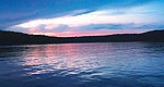
Both canoeing and power boating are popular on the lake, with a good amount of water skiing and other water activities taking place.

Map + Directions


Copyright © 1997 - 2024 The Go Travel Sites. All Rights Reserved and.

Email Page Link

Complete the form below to email this page to a friend or family member's email. You can send yourself an email as well. Your email and your recipient's email will NOT be shared with anyone. See our full Privacy Policy for details.
:
:
:


:
Copy Yourself on the Email Yes No
:
:

1

Select a Free Visitor Guide below

2

Complete the form to receive your guides by mail