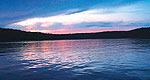
Stretching for 54,000 acres of shimmering blue, the Lake of the Ozarks is large enough to accommodate a veritable throng of anglers, houseboaters and other water-sports enthusiasts.
From Hannibal - Hwy 36 west 17 miles to Hwy J, south 9 miles. From Monroe City - Hwy 36 east 3 miles to Hwy J, south 9 miles. From Paris - Hwy 154 east 20 miles to Hwy J (Perry), north 10 miles. From Perry - Hwy J north 10 miles.
Basic Info
Total Sites:
65
The 32-mile long Joanna Trail is accessible from the campground. Here, horseback riders, mountain bikers and hikers can enjoy the rough and varied terrain that meanders along the northern banks of the lake, across bluffs and over hills.
Campfire programs are provided every Saturday from Memorial Day to Labor Day.
We offer a compact version of Go-Missouri for mobile users, allowing you to access just the information you need on the road. Of course, you can still use the full version of Go-Missouri on your mobile device just as you can on your desktop.